The Austrians: Surrey Ridge

Article and photos by Joe Gschwendtner
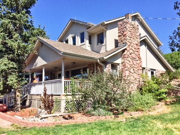
Arthur Ceresa’s home on west side of Clydesdale.

Bulldozed remains of the Kroll Farm and Ranch “Glendale”, north of the dog park, east side I-25, milepost 190.
Joseph Kroll and John Schweiger Sr., likely met in the Leadville mines after emigrating from the Austrian Empire around 1870. With modest savings and presumed collaboration, they found their way to our Wildcat Mountains. Through Homestead Act acquisitions and the diligence of Max and John Schweiger Jr., the families came to control immense tracts of real estate in northern Douglas County. Including another 960 acres owned by Union Pacific Railroad, huge swaths of land from the RidgeGate Exit on I-25 to the southern boundaries of Beverly Hills and a chunk of today’s City of Castle Pines was controlled by the three entities.
The Schweiger family dominated the north end of Douglas County’s I-25 corridor, early on having named their farm and ranch holdings “Happy Can[y]on Ranch” after singing cowboy Jack Johnson. Like-named Happy Canyon Gulch runs from the Wildcat Point area of Daniels Park, through Surrey Ridge, with water currently still flowing to the Schweiger farmhouse at the RidgeGate exit.
John Kroll and his five children took no apparent interest in further expansion, content to manage their section-sized farm/ranch estate. Named Glendale, it sat just east of the dog park parking lot at milepost 190 on I-25. In the best of times, one would have observed their Hereford cattle, chickens and hogs. Crops of alfalfa, wheat, corn and oats were common and apple and cherry orchards were at fields’ end. Mrs. Kroll endured many hardships early on and was known to be deathly afraid of wildcats, abundant in those times.
Schweiger sons Max and John Jr., were aggressive. Before their father died in 1925, they had amassed more land for as little as $2.50 an acre and headquartered their operations on the Happy Canyon Gulch, a tenth of a mile northwest of milepost 190. (At one time, there was an exit 190 on I-25 just south of today’s Journey Church construction, on the west side of the highway.)
Austrian emigrants Arthur and cousin Herman Ceresa found their way to America before World War I. While their early exploits are unknown, by 1937 they had acquired ranch land from the Schweigers. Herman fancied the Kroll parcel, and after Joseph Kroll died in 1940 he secured some of that estate for himself. How much of the Kroll farmstead was used in building his own ranch cannot be visibly discerned from 1937 aerial photos.
Of the Ceresas, Arthur and his wife Mary were the drivers. They built themselves a large two-story ranch house on Clydesdale, several hundred yards northwest of milepost 190. Although a son was born to them, his tragic death in his 20s likely jolted Arthur’s long-term plans. That tragedy alone could not explain the clarity of Arthur Ceresa’s vision for the future development of Douglas County. By the 1960s, Arthur and Mary had consolidated their landholdings into present day Surrey Ridge, Estates and most of Oak Hills. Average price paid? $6.25 an acre.
More to come next month…
Wildcate Lore
As it turns out, The Connection serves residents of the Wildcat Mountains, a name pioneers and historians gave to the high country paralleling I-25 from Highlands Ranch and Lone Tree south to Castle Rock.
Since the first territorial road (Daniels Park Road) bisected our mountains, there was no shortage of colorful characters parading through what are now private properties on the ridges of Douglas County. We bring these grizzled and gutsy settlers alive again, vividly sharing their stories of grit and achievement in these Castle Pines.