Castle Pines North Borders 8,200 Acre Highlands Ranch Open Space
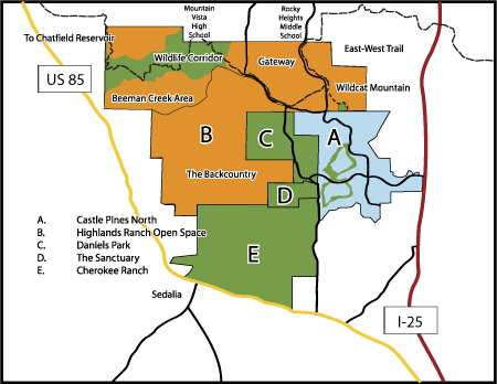
Castle Pines North is fortunate to share its northern and western border with 8,200 acres of open space in the “Backcountry Wilderness” portion of the Highland’s Ranch development.
As recently as the 1970s, Highlands Ranch was still a working cattle ranch and has its share of Colorado history. When the ranch was sold to a developer, the Master Plan for the Highlands Ranch community was to develop the northern two thirds with homes and businesses, while the southern third would be left as open space.
Currently, visitors utilize portions of this open space hiking the Douglas County East-West Regional Trail. The rest of this land is fenced off, with “No Trespassing” signs.
What does the future hold for this land?
According to the Highlands Ranch Master Plan, this parcel of land will never have residential or commercial development. The Master Plan requires that this space be reserved as the “Backcountry Wilderness.” This includes some areas where people can participate in educational and recreational activities related to the natural resources of the land. Other areas will be maintained strictly for wildlife with limited or no access. There will also be an area utilized strictly for agricultural purposes, including a working cattle ranch.
The Master Plan designates specific areas for various uses within the Backcountry Wilderness see the description on page 25 for details. Look at the map on page 14 to find out where these areas lie.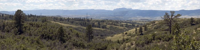
The area where the Backcountry Wilderness backs against CPN on its border to the north and west is simply called the “Backcountry.” The parcel covers more than 3,600 acres and will be managed primarily for wildlife and nature observation. It is recommended that the area only be open to visitors with a guided tour. There may be trails for mountain bikes and/or horses as long as there is no damage to plants or species and trails are sensitive to soil erosion.
Beeman Creek
North from the Backcountry, and visible from Highway 85 (Sante Fe Drive), the Beeman Creek area encompasses the 158 acre Law Enforcement Training Facility. The area surrounding the facility will be managed for wildlife and will not be open to the public.
Wildlife Corridor
Continuing north from the Beeman Creek area is 1,000 acres called the Wildlife Corridor. The Douglas County East-West Regional Trail passes through the Highlands Ranch Backcountry Wilderness in this area. From the trail visitors can view wildlife and scenic views. Highlands Ranch residents will also have access to campsites.
Gateway
Wedged between Daniels Park Road and Monarch Boulevard is 1,200 acres called the Gateway. There are plans for a 200 acre Douglas County Regional Park, located to the southwest of the Rock Canyon and Rocky Heights Middle School complex, that will include ball fields, and other recreational facilities. For the remaining 1,000 acres of the “Gateway” area, zoning allows for various public, cultural and recreational uses for this parcel of land. These uses could include community gardens, wildlife viewing area, equestrian center, golf course, ice arena, fire station, college campus, church, cemetery and an amphitheater. Sections of the Gateway will remain permanently undeveloped to protect wildlife movement and natural drainage. Visitors to the Backcountry will enter through the Gateway.
If this area is designated as open space, why are there signs that say, “No Trespassing – Property of Shea Homes?”
All undeveloped land in Highlands Ranch including the Backcountry, is currently owned by Shea Homes. Once the development reaches build-out, ownership of the open space area will be transferred to the Highlands Ranch Community Association. According to the HRCA Master Plan, this land will never have commericial or residential development.
If this land is open space, why are there fences surrounding the area?
Although the land will always remain open space it is privately owned and not all areas will be accessible to the public. Some designated areas will have public use, including cultural uses, parks, and trails.
Wildcat Mountain Outdoor Education Area
To the east of the Gateway lies the 839 acre Wildcat Mountain Outdoor Education Area. The area is flanked by Monarch Boulevard on the west and Surrey Ridge on the east and encompasses Wildcat Mountain on the north. Hiking, mountain biking, jogging, horseback riding and nature exploration will all be available in this area. Trails will take users to the northern edge of Wildcat Mountain and provide views of downtown Denver and the mountains. Access to the cliffs will be restricted to protect both visitors and the nesting raptors.
When will these plans come to fruition? Who decides?
While the Master Plan defines what could be done, there are many decisions to be made about what will be done, and there is no specific timeline for when any of these enhancements to the area will occur.
Currently, the Backcountry is owned and managed by Shea Homes, the master developer of Highlands Ranch. Once Highlands Ranch reaches build out, which is expected in the next two years, ownership and management will transfer to the Highlands Ranch Community Association (HRCA). Public hearings will be held as decisions are being made.
For more information on the Highlands Ranch Backcountry Wilderness visit the HRCA website at: www.hrcaonline.org