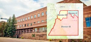
District Representation
Information and graphic provided by Douglas County

You are represented by elected officials at the local, county, state and federal levels. Following the U.S. Census every 10 years, representation districts for these offices can change.
Visit Douglas County’s interactive map to enter your home address and view names of your County Commissioner, along with your representative for State House, State Senate and U.S. Congress.
The Colorado Independent Congressional and Legislative Redistricting Commissions – established in Colorado’s Constitution in 2018 – draw Colorado’s congressional and state legislative districts. Nonpartisan commission staff processed and tabulated the 2020 Census data, incorporating geographic information, in-person and online public comments from commission hearings, and guidance from the commissions to create the new maps, which were approved by the Colorado Supreme Court in November 2021.
County Commissioners are also required to reassess their districts to ensure they are close to equal in population. Douglas County Commissioners approved the updated districts at a public hearing in September 2021.
Voter precincts are also adjusted as a result of the census data to ensure they are contained within the legislative and congressional lines and are less than 2,000 active registered voters. Those adjustments were approved by the Board of County Commissioners in January 2022.
Visit Douglas County’s interactive maps at https://www.douglas.co.us/who-represents-you-check-out-douglas-countys-interactive-map/ to view Voter Precinct, County Commissioner, State House, State Senate and U.S. Congressional District maps.